Thanks to the Detroit Riverfront Conservancy, this year’s Convention attendees had the chance to be wowed by the transformation of Detroit’s waterfront during two mobile workshops and a general session with Conservancy CEO Mark Wallace. While our largest city’s efforts are of course larger than what most of our communities will undertake, many of the lessons from their experience can translate to smaller places.

The Dequindre Cut connects from the Detroit Riverwalk two miles north to Eastern Market along a former rail right-of-way.
Plan long-term, work incrementally
Conservancy staff noted that they do not own the property that the Riverwalk or Dequindre Cut sit on, instead relying on a network of 99-year easements across a patchwork of privately and publicly-owned properties. In fact, after 16 years of work, this effort is still ongoing, and the Conservancy doesn’t yet have control over all the land needed for the ultimate vision.
This experience will be common to riverfront, lakefront, or trail projects in many communities—and that’s okay. Parts of Detroit’s Riverwalk have been completed and in use for a decade, offering great public spaces even while other pieces are still being put together. Treat these projects as a marathon that may take multiple generations of elected or staff leadership to complete: start with the parts that are available, build momentum, and expand from success.

The Conservancy’s Mark Pasco discusses the plans for West Riverfront Park
Don’t give away public access
One missing link in the Riverwalk has been the segment in front of the Riverfront Towers condominiums. Built in the early 1980s on parcels that went to the water’s edge, the condo association was unwilling to allow use of their frontage for the Riverwalk; the conservancy was ultimately able to negotiate a boardwalk in the river to go around the towers’ property. A Riverwalk or similar linear park effort can easily be stymied by a holdout property owner like this—communities should do what they can to avoid having to face these situations.
Where public land along a riverfront or other such feature is sold for development, the community should maintain a public frontage in essentially all cases: where selling rights all the way to the water may boost the value to that single developer and therefore the one-time benefit of the sale price, maintaining it in the public trust provides broader public value in perpetuity. Similarly, any negotiation of development incentives for waterfront property should consider access rights, even if no trail or Riverwalk plans currently exist. If a property is sold or developed without such rights, another chance at that discussion may not arise for several decades.
Design or adapt the space to the people who use it
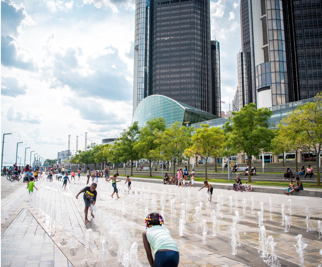
This was not the intended use of this space, but the designers followed the users, and it worked.
Wallace noted that the fountain in GM Plaza, in front of the Ren Cen, was originally envisioned as a sculptural element, rather than an interactive feature, but was quickly adopted by kids as a play area. (A development that could have been predicted by anyone who knows small children!) Rather than trying to obstruct access to the water feature, the Conservancy realized this unintended use was a bonus—but that water features which kids play in need more care taken for water quality, requiring an upgrade to the water supply for the fountain.
A learning process over times of how people want to use the space can be a good thing, and can be anticipated and planned for, rather than treated as a mistake. Temporary pop-ups, or a limited initial construction phase can allow some time to see what people like, or what’s not going to work as planned.
Make programming easy
Placemaking is about people, and nothing attracts people like other people. Making it easy for events large and small to use a space gets residents and visitors accustomed to visiting and adding that place to their routine. This means a place like the Riverwalk needs active management and a clear, easy process for event approval. This doesn’t mean a mandate to say “yes” to everything, because of the need to ensure access to all, provide for public safety, event cleanup, etc., but the requirements placed on an event should be clear and easy to meet, with fast turnaround from place managers.
Natural areas and real estate development aren’t incompatible
Conflicts often arise during discussions of vacant land, especially along water, around perceived zero-sum trade-offs. Dedicating new parkland can be seen as a missed opportunity for economic development or new housing, while construction along natural corridors draws opposition as antithetical to nature. Detroit’s Riverfront shows these purposes can thrive in coordination, with a variety of amphibians, reptiles, and birds in restored natural areas alongside new homes for humans.

That’s an actual heron on the lamppost, not some concocted sculptural element.
In reaching this balance, the design of both aspects is important. Natural spaces that support wildlife (and stormwater management) doesn’t mean either a grassy lawn or just leaving be an overgrown farm field, but requires attention to scale, grading, plant selection, and creation of contiguous corridors. Not to mention education–as Wallace and other Conservancy staff noted, having high-functioning natural ecosystems can involve fielding complaints from park users who think the space is overgrown with “weeds”.
New construction can have the broadest benefit if it prioritizes multi-family apartments or condos, targeted to a mix of income levels, over stand-alone house construction. Additionally, where the footprint of development is large enough to include new streets and blocks, avoid placing long continuous block faces towards the water or natural area—a block pattern that has frequent streets or alleys perpendicular to the natural area will allow the greatest access for residents further into the neighborhood.
Resources
While Detroit’s Riverfront has benefited from substantial private donations, some of the funding sources used are available to other communities statewide:
- The Michigan DNR’s Natural Resources Trust Fund Grants can be used for park and trail project, including both land acquisition and development (construction) costs.
- MDNR Recreation Passport Grants can be used for development of recreation facilities, or renovation of facilities that have outlived their useful life expectancy.
- Federal Land and Water Conservation Grants are reviewed by MDNR for referral to the Federal Government.
All of these grant programs have an April 1st annual application deadline, and require that the local government applicant have an adopted 5-year Recreation Master Plan on file with DNR. Communities interested in applying should discuss their projects with MDNR grants staff well in advance of the deadline.